World Ocean Atlas
Data product of the Ocean Climate Laboratory of the National Oceanographic Data Center (U.S.)
The World Ocean Atlas (WOA) is a data product of the Ocean Climate Laboratory of the National Centers for Environmental Information (U.S.).[1] The WOA consists of a climatology of fields of in situ ocean properties for the World Ocean. It was first produced in 1994[2] (based on the earlier Climatological Atlas of the World Ocean, 1982[3]), with later editions at roughly four year intervals in 1998, 2001, 2005, 2009, 2013, 2018, and 2023.[4]
Dataset
The World Ocean Atlas (WOA) is based on profile data from the World Ocean Database (WOD) Project.[1] The fields that make up the WOA dataset consist of objectively-analysed global grids at 1° spatial resolution. The fields are three-dimensional, and data are typically interpolated onto 33 standardised vertical intervals[5] from the surface (0 m) to the abyssal seafloor (5500 m). In terms of temporal resolution, averaged fields are produced for annual, seasonal and monthly time-scales. The WOA fields include ocean temperature, salinity, dissolved oxygen, apparent oxygen utilisation (AOU), percent oxygen saturation, phosphate, silicic acid, and nitrate. Early editions of the WOA additionally included fields such as mixed layer depth and sea surface height.
In addition to the averaged fields of ocean properties, the WOA also contains fields of statistical information concerning the constituent data that the averages were produced from. These include fields such as the number of data points the average is derived from, their standard deviation and standard error. A lower horizontal resolution (5°) version of the WOA is also available. The WOA dataset is primarily available as compressed ASCII, but since WOA 2005 a netCDF version has also been produced.
Gallery
-
 Annual mean sea surface temperature (WOA 2009)
 -
 Annual mean sea surface salinity (WOA 2009)
 -
 Annual mean sea surface dissolved oxygen (WOA 2009)
 -
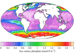 Annual mean sea surface phosphate (WOA 2009)
 -
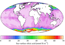 Annual mean sea surface silicic acid (WOA 2009)
 -
 Annual mean sea surface nitrate (WOA 2009)
 -
 Annual mean apparent oxygen utilization at 1000 m depth (WOA 2009)


See also
 Geography portal
 Oceans portal


- CORA dataset
- European Atlas of the Seas
- Geochemical Ocean Sections Study (GEOSECS)
- Global Ocean Data Analysis Project (GLODAP)
- World Ocean Circulation Experiment (WOCE)
References
- ^ a b "ncei.noaa.gov". World Ocean Atlas. 16 June 2021. Retrieved June 10, 2024.
- ^ "World Ocean Atlas 1994 series". National Oceanographic Data Center. 2008-08-29. Retrieved 2008-10-22.
- ^ Levitus, S. (1982). Climatological Atlas of the World Ocean. NOAA/ERL GFDL Professional Paper 13, Princeton, N.J. p. 173 pp.
- ^ "World Ocean Atlas". National Oceanographic Data Center. 16 June 2021. Retrieved 2023-01-14.
- ^ Standardised intervals are at 0, 10, 20, 30, 50, 75, 100, 125, 150, 200, 250, 300, 400, 500, 600, 700, 800, 900, 1000, 1100, 1200, 1300, 1400, 1500, 1750, 2000, 2500, 3000, 3500, 4000, 4500, 5000, 5500 m
External links
- NODC Ocean Climate Laboratory datasets and products
- v
- t
- e
- Airy wave theory
- Ballantine scale
- Benjamin–Feir instability
- Boussinesq approximation
- Breaking wave
- Clapotis
- Cnoidal wave
- Cross sea
- Dispersion
- Edge wave
- Equatorial waves
- Fetch
- Gravity wave
- Green's law
- Infragravity wave
- Internal wave
- Iribarren number
- Kelvin wave
- Kinematic wave
- Longshore drift
- Luke's variational principle
- Mild-slope equation
- Radiation stress
- Rogue wave
- Rossby wave
- Rossby-gravity waves
- Sea state
- Seiche
- Significant wave height
- Soliton
- Stokes boundary layer
- Stokes drift
- Stokes wave
- Swell
- Trochoidal wave
- Tsunami
- Undertow
- Ursell number
- Wave action
- Wave base
- Wave height
- Wave nonlinearity
- Wave power
- Wave radar
- Wave setup
- Wave shoaling
- Wave turbulence
- Wave–current interaction
- Waves and shallow water
- Wind setup
- Wind wave


- Atmospheric circulation
- Baroclinity
- Boundary current
- Coriolis force
- Coriolis–Stokes force
- Craik–Leibovich vortex force
- Downwelling
- Eddy
- Ekman layer
- Ekman spiral
- Ekman transport
- El Niño–Southern Oscillation
- General circulation model
- Geochemical Ocean Sections Study
- Geostrophic current
- Global Ocean Data Analysis Project
- Gulf Stream
- Halothermal circulation
- Humboldt Current
- Hydrothermal circulation
- Langmuir circulation
- Longshore drift
- Loop Current
- Modular Ocean Model
- Ocean current
- Ocean dynamics
- Ocean dynamical thermostat
- Ocean gyre
- Overflow
- Princeton ocean model
- Rip current
- Subsurface currents
- Sverdrup balance
- Thermohaline circulation
- Upwelling
- Wind generated current
- Whirlpool
- World Ocean Circulation Experiment
tectonics
- Acidification
- Argo
- Benthic lander
- Color of water
- DSV Alvin
- Marginal sea
- Marine energy
- Marine pollution
- Mooring
- National Oceanographic Data Center
- Ocean
- Explorations
- Observations
- Reanalysis
- Ocean surface topography
- Ocean temperature
- Ocean thermal energy conversion
- Oceanography
- Pelagic sediment
- Sea surface microlayer
- Sea surface temperature
- Seawater
- Science On a Sphere
- Stratification
- Thermocline
- Underwater glider
- Water column
- World Ocean Atlas
- Oceans portal
 Category
 Commons


