Rechtsupweg
Municipality in Lower Saxony, Germany

Coat of arms
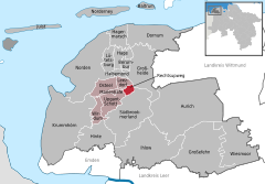
Location of Rechtsupweg within Aurich district
53°31′46″N 7°19′36″E / 53.52944°N 7.32667°E / 53.52944; 7.32667
(2022-12-31)[1]
26529
Rechtsupweg is a municipality in the district of Aurich, in Lower Saxony, Germany.
References
- ^ "LSN-Online Regionaldatenbank, Tabelle A100001G: Fortschreibung des Bevölkerungsstandes, Stand 31. Dezember 2022" (in German). Landesamt für Statistik Niedersachsen.
- v
- t
- e
Towns and municipalities in Aurich (district)
- Aurich
- Baltrum
- Berumbur
- Dornum
- Großefehn
- Großheide
- Hage
- Hagermarsch
- Halbemond
- Hinte
- Ihlow
- Juist
- Krummhörn
- Leezdorf
- Lütetsburg
- Marienhafe
- Norden
- Norderney
- Osteel
- Rechtsupweg
- Südbrookmerland
- Upgant-Schott
- Wiesmoor
- Wirdum

Authority control databases | |
|---|---|
| International |
|
| National |
|
 | This Aurich (district) location article is a stub. You can help Wikipedia by expanding it. |
- v
- t
- e


