Neepaulakating Creek
Tributary of Papakating Creek
41°13′23″N 74°38′03″W / 41.22306°N 74.63417°W / 41.22306; -74.63417
• coordinates
• elevation
Rondout Creek, Hudson River)
Neepaulakating Creek is a 2.4-mile long (3.8 km) tributary of Papakating Creek in Wantage Township in Sussex County, New Jersey in the United States.[1][2] It is one of three streams feeding the Papakating Creek, a major contributor to the Wallkill River. Although the stream was dammed in the 1950s to create Lake Neepaulin as the focal point of a private residential development, the stream did not receive a name until 2002. Residents chose a name that combined elements of the names "Neepaulin" and "Papakating", and submitted a proposal to the United States Board of Geographic Names. The name was approved in 2004.
Course and watershed
Neepaulakating Creek is small stream whose headwaters are located at 640 feet (200 m) above sea level approximately 0.4 miles (0.64 km) northwest of the north end of Lake Neepaulin.[1][2][3] These headwaters are located a short distance south of County Route 650 (Libertyville Road) roughly halfway between the hamlet of Libertville in Wantage Township and Sussex Borough.[2][4] The stream flows into Lake Neepaulin located at 509 ft (155 m) above sea level.[5] The man-made lake, created through damming, is the centre of a private residential development.[6] It flows southeast from the lake's dam in the southeast direction for another 1.5 miles (2.4 km) before flowing into Papakating Creek. It enters Papakating Creek at 395 feet (120 m) above sea level approximately 2.5 miles (4.0 km) upstream of that creek's junction with the Wallkill River at a location directly south of Sussex Borough along County Route 565 near the hamlet of Lewisburg in Wantage Township and near Sussex Airport.[1][2][3][7]
Along with the Clove Brook and West Branch Papakating Creek, Neepaulakating Creek is one of the tributaries that form the 60.6 square miles (157 km2) watershed of Papakating Creek, a major tributary of the Wallkill River. The Papakating Creek watershed is located in the Kittatinny Valley, is underlain by dark shale and limestone of the Martinsburg Formation, and has soils of glacial origin. The topography of the Papakating Creek's watershed ranges from gentle slopes in the east to steeper slopes in the west.[8][9] According to the New Jersey Department of Environmental Protection (NJDEP), the Papakating watershed consists of gently sloping farmland, forested land, wetlands, older individually built homes, and low-density residential development.[10]
According to NJDEP reports, two developed lake communities in the Papakating Creek watershed—Lake Neepaulin and the nearby Clove Acres Lake contribute to phosphorus loading in the waters of Papakating Creek. The phosphorus loading may originate from the runoff of fertilizer applications on residential lawns, nearby agricultural operations, or from large populations of geese that inhabit the lakes.[10]
History and naming
In the 1950s, a real estate developer dammed an unnamed stream located to the west and south of Sussex Borough and created Lake Neepaulin. The lake was the center of a planned private lakeside residential community.[6] In 2002, an organization known as Friends of Lake Neepaulin, began using "Neepaulakating Creek" as a new name for an unnamed stream that was dammed to create the lake.[3] After a review of resources available on the internet, topographic maps, and other government and historical documents, a state engineer reported there was no evidence the stream had any previous name.[11] The name chosen, Neepaulakating, was a combination of portions of the names "Neepaulin" and "Papakating". Lake Neepaulin was named after a combination of the original developers children's names.[1][3][12]
A formal proposal prepared by the residents was submitted to the Board of Geographic Names by Nathaniel Sajdak, described as the Outreach Coordinator of the Wallkill River Watershed and a member of Friends of Lake Neepaulin.[3] Sajdak reported to the United States Geological Survey's Board of Geographic Names that studies such as visual and biological assessments were carried out on the unnamed stream by the Lake Neepaulin Lake Association for roughly two years, during which time they had begun to call it "Neepaulakating Creek".[3] On February 25, 2004, the Sussex County Board of Chosen Freeholders unanimously approved a resolution to support the naming, stating that the county government "defers to the Township of Wantage and concurs with the naming of the tributary as 'Neepaulakating Creek'".[13] On April 8, 2004, the Board of Geographic Names approved the proposal.[14]
Gallery
-
 Neepaulakating Creek near its headwaters
 -
 Lake Neepaulin looking northwest from the dam
 -
 Lake Neepaulin dam
 -
 Looking southeast (downstream) from the dam
 -
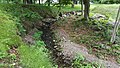
 The creek and marsh near Newton Avenue in Wantage
 -
 The creek before it flows under County Route 639


See also
References
- ^ a b c d e United States Geological Survey, Geographic Names Information System, Feature Detail Report for: Neepaulakating Creek. Retrieved June 26, 2015.
- ^ a b c d e United States Geological Survey. National Hydrography Dataset high-resolution flowline data. The National Map. Retrieved June 26, 2015. Note: The upper elevation of its headwaters is approximately 640 feet above mean sea level derived from a reading of the USGS NHD topographic map. The NHD information provides the elevation the mouth at 395 feet above mean sea level. See also: United States Geological Survey, Hamburg, NJ Quadrangle USGS 1:24 Topographic Map 41074B5 and Branchville, NJ Quadrangle USGS 1:24 Topographic Map 41074B4.
- ^ a b c d e f Friends of Lake Neepaulin, Nathaniel Sajdak, Jennifer E. Runyon (USGS), United States Board of Geographic Names, Case Brief: Neepaulakating Creek (2002). Retrieved June 26, 2015.
- ^ Google, Inc., Google Maps location for 41°13'23.3"N 74°38'01.6"W (source). Retrieved June 27, 2015.
- ^ United States Geological Survey, Geographic Names Information System, Feature Detail Report for: Lake Neepaulin. Retrieved July 20, 2015.
- ^ a b Eric Oberhauer, "Wantage resident suing over costs of Lake Neepaulin dam", The New Jersey Herald, April 22, 2012.
- ^ Google, Inc., Google Maps location for 41°11'56.7"N 74°36'40.4"W (mouth). Retrieved June 27, 2015.
- ^ Avery Ala Drake Jr., Richard A. Volkert, Donald H. Monteverde, Gregory C. Herman, Hugh F. Houghton, Ronald A. Parker, and Richard F. Dalton, I2540a: Bedrock geologic map of northern New Jersey, IMAP. (Washington DC: United States Geological Survey, 1997). Retrieved 22 July 2015.
- ^ New Jersey Department of Environmental Protection, Division of Watershed Management, Amendment to the Sussex County Water Quality Management Plan: Total Maximum Daily Load to Address Phosphorus in the Clove Acres Lake and Papakating Creek Northwest Water Region (2004), 9, 15. Retrieved June 26, 2015.
- ^ a b New Jersey Department of Environmental Protection, State Development & Redevelopment Plan. Plan Endorsement Opportunities & Constraints: Analysis for Township of Frankford, Sussex County (2009), 14, 16. Retrieved June 26, 2015.
- ^ Correspondence from William P. Graff (NJDEP) to Roger L. Payne (USGS) (September 9, 2002). Retrieved June 26, 2015.
- ^ E-mail corresponsdence Jim Rementer (Lenape Language Project) to Jennifer E. Runyon, USGS BGN (March 24, 2004). Retrieved June 26, 2015.
- ^ Sussex County Board of Chosen Freeholders, Resolution Re: Support of the submission of a proposal by the Township of Wantage to the U.S. Board on Geographic Names regarding the naming of a tributary in Sussex County "Neepaulakating Creek" (February 25, 2004). Retrieved June 26, 2015.
- ^ Letter from Roger L. Payne (USGS) to James L. Doherty (Wantage Township Administrator Clerk) (April 30, 2004). Retrieved June 26, 2015. Quote: "U.S. Board on Geographic Names, at its April 8, 2004, meeting, approved the proposal to name an unnamed stream in Sussex County, Neepaulakating Creek. This decision was made in agreement with the findings and recommendations of your office, the government of Sussex County, and the New Jersey Board on Geographic Names."
External links
- Wallkill River Watershed Management Group
- v
- t
- e
Hudson River watershed
- Batavia Kill
- Batten Kill
- Birch Creek
- Black Meadow Creek
- Boreas River
- Bowery Creek
- Bowmans Creek
- Breakneck Brook
- Brimstone Creek
- Canajoharie Creek
- Caroga Creek
- Casperkill
- Catskill Creek
- Cayadutta Creek
- Cedar River
- Claverack Creek
- Clove Brook
- Cobleskill Creek
- Coeymans Creek
- Coxsackie Creek
- Cross River
- Croton River
- East Branch Croton River
- East Branch Sacandaga River
- East Canada Creek
- East Kill
- Eightmile Creek
- Esopus Creek
- Fall Kill
- Fishkill Creek
- Fonteyn Kill
- Fulmer Creek
- Hannacrois Creek
- Honnedaga Brook
- Hoosic River
- Indian River
- Jackson Creek
- Jan De Bakkers Kill
- Kaaterskill Creek
- Kayaderosseras
- Kinderhook Creek
- Kisco River
- Lake Creek
- Little Shawangunk Kill
- Maritje Kill
- Miami River
- Mill Creek
- Mohawk River
- Moodna Creek
- Moordener Kill
- Moyer Creek
- Muddy Kill
- Neepaulakating Creek
- Normans Kill
- Nowadaga Creek
- Ohisa Creek
- Onesquethaw Creek
- Opalescent River
- Oriskany Creek
- Otsquago Creek
- Otter Kill
- Papakating Creek
- Peekskill Hollow Creek
- Plattekill Creek
- Platter Kill
- Pocantico River
- Pochuck Creek
- Poesten Kill
- Potic Creek
- Quassaick Creek
- Roeliff Jansen Kill
- Rondout Creek
- Sacandaga River
- Sauquoit Creek
- Saw Kill
- Saw Mill River
- Sawyer Kill
- Schoharie Creek
- Schroon River
- Shawangunk Kill
- Sparkill Creek
- Sprout Creek
- Steele Creek
- Stockport Creek
- Stony Clove Creek
- Taghkanic Creek
- Tenmile Creek
- Tin Brook
- Titicus River
- Trout Brook
- Verkeerder Kill
- Vloman Kill
- Wallkill River
- Walloomsac River
- Wappinger Creek
- Wawayanda Creek
- West Branch Papakating Creek
- West Branch Sacandaga River
- West Canada Creek
- West Kill
- Wynants Kill
- Alcove Reservoir
- Ashokan Reservoir
- Basic Creek Reservoir
- Beacon Reservoir
- Bog Brook Reservoir
- Cedar Lake
- Chadwick Lake
- Chub Lake
- Cross River Reservoir
- Croton Falls Reservoir
- Dyken Pond
- East Branch Reservoir
- East Caroga Lake
- Fall Lake
- Franklinton Vlaie
- Garnet Lake
- Glenmere Lake
- Great Sacandaga Lake
- Great Vlaie
- Henderson Lake
- Honnedaga Lake
- Indian Lake
- Lizard Pond
- Lake Maratanza
- Muscoot Reservoir
- Lake Neepaulin
- New Croton Reservoir
- Notch Lake
- Piseco Lake
- Lake Pleasant
- Queechy Lake
- Rondout Reservoir
- Sacandaga Lake
- Saratoga Lake
- Sturgeon Pool
- Surprise Lake
- Sylvan Lake
- Lake Tear of the Clouds
- Thompson Pond
- Titicus Reservoir
- Trout Lake
- West Caroga Lake
- Whaley Lake
- Winnisook Lake
| New York |
|
|---|---|
| New Jersey |
- Adirondack Mountains
- Adirondack Park
- Ashokan Bridge
- Blenheim Bridge
- Buskirk Bridge
- Catskill Mountains
- Champlain Canal
- Cohoes Falls
- Copeland Bridge
- Delaware and Hudson Canal
- Eagleville Bridge
- East River
- Erie Canal
- George Washington Bridge
- Harlem River
- Helderberg Escarpment
- Holland Tunnel
- Hudson Highlands State Park
- Kaaterskill Clove
- Kaaterskill Falls
- Kill Van Kull
- Kingston–Rhinecliff Bridge
- Lincoln Tunnel
- Mid-Hudson Bridge
- Newburgh–Beacon Bridge
- Tappan Zee Bridge (2017–present)
- The Palisades
- Perrine's Bridge
- Plotter Kill Preserve
- Pollepel Island
- Popolopen
- Rexleigh Bridge
- Rip Van Winkle Bridge
- Salisbury Center Bridge
- Schoharie Bridge
- Shushan Bridge
- Statue of Liberty
- Taconic Mountains
- Verkeerder Kill Falls
- Walkway over the Hudson
- Wallkill River National Wildlife Refuge
- West Canada Lake Wilderness Area


