National Register of Historic Places listings in Lamar County, Georgia
This is a list of properties and districts in Lamar County, Georgia that are listed on the National Register of Historic Places (NRHP).
Map all coordinates using OpenStreetMap
Download coordinates as:
- KML
- GPX (all coordinates)
- GPX (primary coordinates)
- GPX (secondary coordinates)
This National Park Service list is complete through NPS recent listings posted June 28, 2024.[1]
- v
- t
- e
Properties on the National Register of Historic Places in Georgia by county
- Appling
- Atkinson
- Bacon
- Baker
- Baldwin
- Banks
- Barrow
- Bartow
- Ben Hill
- Berrien
- Bibb
- Bleckley
- Brantley
- Brooks
- Bryan
- Bulloch
- Burke
- Butts
- Calhoun
- Camden
- Candler
- Carroll
- Catoosa
- Charlton
- Chatham
- Chattahoochee
- Chattooga
- Cherokee
- Clarke
- Clay
- Clayton
- Clinch
- Cobb
- Coffee
- Colquitt
- Columbia
- Cook
- Coweta
- Crawford
- Crisp
- Dade
- Dawson
- Decatur
- DeKalb
- Dodge
- Dooly
- Dougherty
- Douglas
- Early
- Echols
- Effingham
- Elbert
- Emanuel
- Evans
- Fannin
- Fayette
- Floyd
- Forsyth
- Franklin
- Fulton
- Gilmer
- Glascock
- Glynn
- Gordon
- Grady
- Greene
- Gwinnett
- Habersham
- Hall
- Hancock
- Haralson
- Harris
- Hart
- Heard
- Henry
- Houston
- Irwin
- Jackson
- Jasper
- Jeff Davis
- Jefferson
- Jenkins
- Johnson
- Jones
- Lamar
- Lanier
- Laurens
- Lee
- Liberty
- Lincoln
- Long
- Lowndes
- Lumpkin
- Macon
- Madison
- Marion
- McDuffie
- McIntosh
- Meriwether
- Miller
- Mitchell
- Monroe
- Montgomery
- Morgan
- Murray
- Muscogee
- Newton
- Oconee
- Oglethorpe
- Paulding
- Peach
- Pickens
- Pierce
- Pike
- Polk
- Pulaski
- Putnam
- Quitman
- Rabun
- Randolph
- Richmond
- Rockdale
- Schley
- Screven
- Seminole
- Spalding
- Stephens
- Stewart
- Sumter
- Talbot
- Taliaferro
- Tattnall
- Taylor
- Telfair
- Terrell
- Thomas
- Tift
- Toombs
- Towns
- Treutlen
- Troup
- Turner
- Twiggs
- Union
- Upson
- Walker
- Walton
- Ware
- Warren
- Washington
- Wayne
- Webster
- Wheeler
- White
- Whitfield
- Wilcox
- Wilkes
- Wilkinson
- Worth

Current listings
| [2] | Name on the Register | Image | Date listed[3] | Location | City or town | Description |
|---|---|---|---|---|---|---|
| 1 | Barnesville Commercial Historic District |  | June 20, 1995 (#95000733) | Roughly bounded by College, Taylor and Market Sts. and the Central of GA RR tracks 33°03′17″N 84°09′18″W / 33.054722°N 84.155°W / 33.054722; -84.155 (Barnesville Commercial Historic District) | Barnesville | |
| 2 | Barnesville Depot |  | April 30, 1986 (#86000916) | Plaza Way and Main St. 33°03′16″N 84°09′21″W / 33.054444°N 84.155833°W / 33.054444; -84.155833 (Barnesville Depot) | Barnesville | Built in 1912 |
| 3 | Carnegie Library of Barnesville | 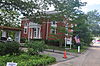 | February 3, 1987 (#86003684) | Library St. 33°03′10″N 84°09′30″W / 33.052778°N 84.158333°W / 33.052778; -84.158333 (Carnegie Library of Barnesville) | Barnesville | |
| 4 | Benjamin Gachet House |  | April 17, 1997 (#97000301) | GA 18, 3 mi. W of Barnesville 33°03′40″N 84°12′30″W / 33.061161°N 84.208448°W / 33.061161; -84.208448 (Benjamin Gachet House) | Barnesville | |
| 5 | Johnstonville-Goggins Historic District |  | November 2, 2000 (#00001283) | Johnstonville Road, west of Interstate 75 33°05′22″N 84°04′27″W / 33.089333°N 84.074222°W / 33.089333; -84.074222 (Johnstonville-Goggins Historic District) | Johnstonville | |
| 6 | Lamar County Courthouse |  | September 18, 1980 (#80001103) | Thomaston St. 33°03′08″N 84°09′22″W / 33.052222°N 84.156111°W / 33.052222; -84.156111 (Lamar County Courthouse) | Barnesville | |
| 7 | Redbone Community House | Upload image | April 9, 1998 (#98000323) | Community House Rd., jct. with Sappington Rd. 32°59′22″N 84°05′50″W / 32.989444°N 84.097222°W / 32.989444; -84.097222 (Redbone Community House) | Barnesville | |
| 8 | Thomaston Street Historic District |  | July 28, 1995 (#95000908) | Roughly, along Thomaston and Greenwood Sts. and Stafford and Georgia Aves. 33°02′46″N 84°09′35″W / 33.046111°N 84.159722°W / 33.046111; -84.159722 (Thomaston Street Historic District) | Barnesville |
References
- ^ National Park Service, United States Department of the Interior, "National Register of Historic Places: Weekly List Actions", retrieved June 28, 2024.
- ^ Numbers represent an alphabetical ordering by significant words. Various colorings, defined here, differentiate National Historic Landmarks and historic districts from other NRHP buildings, structures, sites or objects.
- ^ The eight-digit number below each date is the number assigned to each location in the National Register Information System database, which can be viewed by clicking the number.
Wikimedia Commons has media related to National Register of Historic Places in Lamar County, Georgia.


