List of National Historic Landmarks in Iowa


The Farm House
Phipps Site
Van Allen

Army School Terrace Hill

Dubuque's Mines William M. Black Dubuque County Jail
Blood Run

Merchants' National Bank
George M. Verity
Lone Star
Amana Colonies
Woodbury Courthouse Floyd Monument Sergeant Floyd
Indian Village
Toolesboro Mound
Kimball Village
class=notpageimage|
Iowa National Historic Landmarks (clickable map)The List of National Historic Landmarks in Iowa contains the landmarks designated by the U.S. Federal Government for the U.S. state of Iowa.
There are 28 National Historic Landmarks (NHLs) in Iowa.
- Key
Map all coordinates using OpenStreetMap
Download coordinates as:
- KML
- GPX (all coordinates)
- GPX (primary coordinates)
- GPX (secondary coordinates)
| National Historic Landmark | |
| † | National Historic Landmark District |
| # | National Historical Park |
| § | National Historic Site |
| * | Delisted Landmark |
Current NHLs
Map all coordinates using OpenStreetMap
Download coordinates as:
- KML
- GPX (all coordinates)
- GPX (primary coordinates)
- GPX (secondary coordinates)
| [1] | Landmark name | Image | Date designated[2] | Location | County | Description |
|---|---|---|---|---|---|---|
| 1 | Amana Colonies |  | June 23, 1965 (#66000336) | Middle Amana 41°47′59″N 91°55′15″W / 41.799722°N 91.920833°W / 41.799722; -91.920833 (Amana Colonies) | Iowa | Amana Villages community, historic and modern. |
| 2 | Blood Run Site | 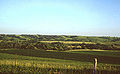 | May 22, 1970 (#70000246) | Granite, IA and Shindler, SD 43°28′N 96°35′W / 43.47°N 96.58°W / 43.47; -96.58 (Blood Run Site) | Lyon, IA and Lincoln, SD | An archaeological site, overlapping into South Dakota. |
| 3 | Davis Oriole Earthlodge Site |  | October 16, 2012 (#12001018) | Glenwood 41°04′16″N 95°47′12″W / 41.071111°N 95.786667°W / 41.071111; -95.786667 (Davis Oriole Earthlodge Site) | Mills | A well-preserved Plains Indian lodge archaeological site; located in Pony Creek Park |
| 4 | Grenville M. Dodge House |  | November 5, 1961 (#66000338) | Council Bluffs 41°15′18″N 95°50′53″W / 41.25513°N 95.84813°W / 41.25513; -95.84813 (Grenville M. Dodge House) | Pottawattamie | Home of Civil War General and Union Pacific Chief Engineer Grenville Dodge. |
| 5 | Dubuque County Jail | 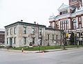 | May 28, 1987 (#72000473) | Dubuque 42°30′06″N 90°39′53″W / 42.50154°N 90.66470°W / 42.50154; -90.66470 (Dubuque County Jail) | Dubuque | Example of the uncommon Egyptian Revival architectural style. |
| 6 | The Farm House |  | July 19, 1964 (#66000339) | Ames 42°01′41″N 93°38′32″W / 42.02807°N 93.64222°W / 42.02807; -93.64222 (The Farm House) | Story | Home of agriculturist and teacher Seagram A. Knapp and of U.S. Secretary of Agriculture James Wilson, now on Iowa State University campus. |
| 7 | Fort Des Moines Provisional Army Officer Training School |  | May 30, 1974 (#74000805) | Des Moines 41°31′36″N 93°36′55″W / 41.526606°N 93.615233°W / 41.526606; -93.615233 (Fort Des Moines Provisional Army Officer Training School) 41°31′36″N 93°36′55″W / 41.526606°N 93.615233°W / 41.526606; -93.615233 (Fort Des Moines Provisional Army Officer Training School) | Polk | Training site for black officers in World War I. |
| 8 | George M. Verity (towboat) |  | December 20, 1989 (#89002459) | Keokuk 40°23′29″N 91°22′21″W / 40.39129°N 91.37250°W / 40.39129; -91.37250 (George M. Verity (towboat)) | Lee | One of three surviving steam-powered towboats in the United States, this ship pioneered on upper Mississippi in a certain way, leading to large private industry. |
| 9 | William P. Hepburn House |  | December 8, 1976 (#73000736) | Clarinda 40°44′30″N 95°02′31″W / 40.741667°N 95.041806°W / 40.741667; -95.041806 (William P. Hepburn House) | Page | Home of eleven-term Congressman William B. Hepburn. |
| 10 | Reverend George B. Hitchcock House |  | February 17, 2006 (#77000500) | Lewis 41°18′12″N 95°06′12″W / 41.30325°N 95.103472°W / 41.30325; -95.103472 (Reverend George B. Hitchcock House) | Cass | Used as a "station" on the Underground Railway. |
| 11 | Herbert Hoover Birthplace |  | June 23, 1965 (#66000110) | West Branch 41°40′07″N 91°20′53″W / 41.668611°N 91.348056°W / 41.668611; -91.348056 (Herbert Hoover Birthplace) | Cedar | Two-room cottage birthplace of Herbert Hoover, 31st U.S. President. |
| 12 | Indian Village Site (Witrock Area) |  | July 19, 1964 (#66000888) | Sutherland 42°58′50″N 95°25′22″W / 42.98055556°N 95.42277778°W / 42.98055556; -95.42277778 (Indian Village Site (Witrock Area)) | O'Brien | An archaeological site. |
| 13 | Kimball Village Site |  | December 23, 2016 (#100000835) | Westfield | Plymouth | Late Prehistoric Plains Village site. |
| 14 | Lone Star (towboat) |  | December 20, 1989 (#89002461) | LeClaire 41°35′54″N 90°20′33″W / 41.598303°N 90.342553°W / 41.598303; -90.342553 (Lone Star (towboat)) | Scott | Oldest of the three surviving steam-powered towboats in the United States. |
| 15 | Merchants' National Bank |  | January 7, 1976 (#76000804) | Grinnell 41°44′32″N 92°43′33″W / 41.74229°N 92.72580°W / 41.74229; -92.72580 (Merchants' National Bank) | Poweshiek | Louis Sullivan-designed bank building on a corner in Grinnell. |
| 16 | Julien Dubuque's Mines |  | November 4, 1993 (#88002662) | Dubuque 42°28′07″N 90°38′47″W / 42.468739°N 90.646311°W / 42.468739; -90.646311 (Julien Dubuque's Mines) | Dubuque | Historic district including Julien Dubuque Monument and archaeological sites relating to early lead mining in area. |
| 17 | Old Capitol |  | January 7, 1976 (#72000475) | Iowa City 41°39′34″N 91°32′08″W / 41.65943°N 91.53565°W / 41.65943; -91.53565 (Old Capitol) | Johnson | It is one of the five-building Pentacrest, another NRHP. |
| 18 | Phipps Site | Upload image | July 19, 1964 (#66000335) | Cherokee | Cherokee | An archaeological site. |
| 28 | Pottawattamie County Jail and Sheriff’s Residence |  | December 11, 2023 (#100009825) | Council Bluffs 41°16′35″N 95°50′39″W / 41.276389°N 95.844167°W / 41.276389; -95.844167 (Pottawattamie County Jail and Sheriff’s Residence) | Pottawattamie | One of very few surviving rotary jails. |
| 19 | Sergeant Floyd (towboat) |  | May 5, 1989 (#89001079) | Sioux City 42°29′28″N 96°25′07″W / 42.491175°N 96.418581°W / 42.491175; -96.418581 (Sergeant Floyd (towboat)) | Woodbury | Another of just 3 steam-powered towboats surviving. |
| 20 | Sergeant Floyd Monument |  | June 30, 1960 (#66000340) | Sioux City 42°27′38″N 96°22′39″W / 42.46068°N 96.37753°W / 42.46068; -96.37753 (Sergeant Floyd Monument) | Woodbury | Monument to the only member of the 1805 Lewis and Clark Expedition who died during the trip. This is the first National Historic Landmark in the United States. |
| 21 | Surf Ballroom |  | January 13, 2021 (#100006243) | Clear Lake 43°08′24″N 93°23′23″W / 43.139916°N 93.389633°W / 43.139916; -93.389633 (Surf Ballroom) | Cerro Gordo | A Historic Rock and Roll Landmark where Buddy Holly, Ritchie Valens, and J. P. "The Big Bopper" Richardson gave their last performances on February 2, 1959, as part of the "Winter Dance Party Tour." They died the following day in a plane crash known colloquially as "The Day the Music Died." |
| 22 | Terrace Hill |  | July 31, 2003 (#03001036) | Des Moines 41°35′00″N 93°38′56″W / 41.583333°N 93.648889°W / 41.583333; -93.648889 (Terrace Hill) | Polk | Governor's mansion on hilltop in what is now downtown Des Moines. |
| 23 | Toolesboro Mound Group |  | May 23, 1966 (#66000337) | Toolesboro 41°09′N 91°03′W / 41.15°N 91.05°W / 41.15; -91.05 (Toolesboro Mound Group) | Louisa | Mound site. |
| 24 | Van Allen and Company Department Store |  | January 7, 1976 (#76000753) | Clinton 41°50′28″N 90°11′18″W / 41.84121°N 90.18822°W / 41.84121; -90.18822 (Van Allen and Company Department Store) | Clinton | A Louis Sullivan-designed 4 story building, now apartments over commercial space. |
| 25 | James B. Weaver House | 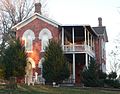 | May 15, 1975 (#75000680) | Bloomfield 40°45′19″N 92°24′45″W / 40.755333°N 92.412611°W / 40.755333; -92.412611 (James B. Weaver House) | Davis | Home of Congressman and presidential candidate James Weaver. |
| 26 | William M. Black (dredge) |  | April 27, 1992 (#82002618) | Dubuque 42°29′43″N 90°39′44″W / 42.495410°N 90.662156°W / 42.495410; -90.662156 (William M. Black (dredge)) | Dubuque | Sidewheel dredge operated by U.S. Corps of Engineers. |
| 27 | Woodbury County Courthouse |  | June 19, 1996 (#73000744) | Sioux City 42°29′50″N 96°24′20″W / 42.497158°N 96.405525°W / 42.497158; -96.405525 (Woodbury County Courthouse) | Woodbury | One of finest Prairie School buildings in the United States. |
Former Iowa NHLs
- President (steamboat) formerly in Davenport, Iowa, relocated to Mississippi and thence to Alton, Illinois
National Park Service areas in Iowa
- Effigy Mounds National Monument
- Herbert Hoover National Historic Site (also an NHL, listed above)
See also
- National Register of Historic Places listings in Iowa
- List of National Historic Landmarks by state
- List of National Natural Landmarks in Iowa
References
- ^ Numbers represent an alphabetical ordering by significant words. Various colorings, defined here, differentiate National Historic Landmarks and historic districts from other NRHP buildings, structures, sites or objects.
- ^ The eight-digit number below each date is the number assigned to each location in the National Register Information System database, which can be viewed by clicking the number.
External links
Map all coordinates using OpenStreetMap
Download coordinates as:
- KML
- GPX (all coordinates)
- GPX (primary coordinates)
- GPX (secondary coordinates)
- "National Historic Landmarks Survey: List of National Historic Landmarks by State--Iowa (24)" (PDF). National Park Service. Retrieved October 10, 2007.
- National Historic Landmarks Program, at National Park Service
- v
- t
- e
- Alabama
- Alaska
- Arizona
- Arkansas
- California
- Colorado
- Connecticut
- Delaware
- Florida
- Georgia
- Hawaii
- Idaho
- Illinois
- Indiana
- Iowa
- Kansas
- Kentucky
- Louisiana
- Maine
- Maryland
- Massachusetts
- Michigan
- Minnesota
- Mississippi
- Missouri
- Montana
- Nebraska
- Nevada
- New Hampshire
- New Jersey
- New Mexico
- New York
- North Carolina
- North Dakota
- Ohio
- Oklahoma
- Oregon
- Pennsylvania
- Rhode Island
- South Carolina
- South Dakota
- Tennessee
- Texas
- Utah
- Vermont
- Virginia
- Washington
- West Virginia
- Wisconsin
- Wyoming
| Insular area | |
|---|---|
| Associated state | |
| Foreign country |
| |
|---|---|
| Topics | |
| Lists by state |
|
| Lists by insular areas | |
| Lists by associated state | |
| Other areas | |
| Related | |
| |


