Krásny Brod
Municipality in Slovakia
49°14′N 21°54′E / 49.233°N 21.900°E / 49.233; 21.900 Slovakia
 (2021)
067 03[3]
Krásny Brod (Rusyn: Красный Брід; Ukrainian: Красний Брід; Hungarian: Laborcrév) is a village and municipality in the Medzilaborce District in the Prešov Region of far north-eastern Slovakia.
History
In historical records the village was first mentioned in 1557. Before the establishment of independent Czechoslovakia in 1918, it was part of Zemplén County within the Kingdom of Hungary. From 1939 to 1944, it was part of the Slovak Republic. In 1944, the Red Army dislodged the Wehrmacht from Krásny Brod and it was once again part of Czechoslovakia.
Geography
The municipality lies at an altitude of 301 metres and covers an area of 15.113 km2. It has a population of about 425 people.
Gallery
-
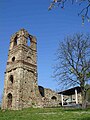 Ruins of the old Basilian monastery of the Descent of the Holy Spirit in Krásny Brod (est. 14th century)
 -
 Ruins of the old Basilian monastery of the Descent of the Holy Spirit in Krásny Brod (est. 14th century)
 -
 Ruins of the old Basilian monastery of the Descent of the Holy Spirit in Krásny Brod (est. 14th century)
 -
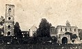 Ruins of the old Basilian monastery of the Descent of the Holy Spirit in Krásny Brod (est. 14th century) in 1930
 -
 Information on the old Basilian monastery of the Descent of the Holy Spirit in Krásny Brod (est. 14th century)
 -
 Derelict manor house in Krásny Brod
 -
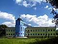 New Basilian monastery in Krásny Brod
 -
 Orthodox church in Krásny Brod
 -
 Orthodox church in Krásny Brod
 -
 Funeral home at cemetery in Krásny Brod


References
- ^ "Počet obyvateľov podľa pohlavia - obce (ročne)". www.statistics.sk (in Slovak). Statistical Office of the Slovak Republic. 2022-03-31. Retrieved 2022-03-31.
- ^ a b "Hustota obyvateľstva - obce [om7014rr_ukaz: Rozloha (Štvorcový meter)]". www.statistics.sk (in Slovak). Statistical Office of the Slovak Republic. 2022-03-31. Retrieved 2022-03-31.
- ^ a b c d "Základná charakteristika". www.statistics.sk (in Slovak). Statistical Office of the Slovak Republic. 2015-04-17. Retrieved 2022-03-31.
- ^ a b "Hustota obyvateľstva - obce". www.statistics.sk (in Slovak). Statistical Office of the Slovak Republic. 2022-03-31. Retrieved 2022-03-31.
External links
 Media related to Krásny Brod at Wikimedia Commons
- Official website

- https://web.archive.org/web/20080111223415/http://www.statistics.sk/mosmis/eng/run.html

Authority control databases | |
|---|---|
| International |
|
| National |
|
 | This Prešov Region geography article is a stub. You can help Wikipedia by expanding it. |
- v
- t
- e


