Hunter–Fryingpan Wilderness
Protected area in Colorado, US
39°12′00″N 106°37′00″W / 39.20000°N 106.61667°W / 39.20000; -106.61667[2]The Hunter–Fryingpan Wilderness is a U.S. Wilderness Area located in White River National Forest east of Aspen, Colorado. The 82,026-acre (331.95 km2) wilderness established in 1978 includes the headwaters of Hunter Creek and the Fryingpan River plus many peaks of the Williams Mountains. It borders on the Mount Massive Wilderness to the east, separated only by the continental divide. There are 50 miles (80 km) of trails in the wilderness area.[3][4]
Photo gallery
-
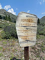 Wilderness sign
 -
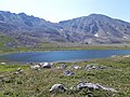 Independence Lake
 -
 Lost Man Lake


References
- ^ Protected Area Profile for Hunter–Fryingpan Wilderness from the World Database on Protected Areas. Retrieved May 2 2023.
- ^ "Hunter-Fryingpan Wilderness". Geographic Names Information System. United States Geological Survey, United States Department of the Interior. Retrieved August 10, 2012.
- ^ "Hunter=Fryingpan Wilderness". Wilderness.net. Retrieved August 10, 2012.
- ^ "Hunter-Fryingpan Wilderness". Colorado Wilderness. Retrieved August 10, 2012.
Wikimedia Commons has media related to Hunter-Fryingpan Wilderness.
- v
- t
- e

| 43 State Parks |
|
|---|---|
| 1 State Forest | |
| 307 State Wildlife Areas | |
| 96 State Natural Areas |
|
| 26 Scenic and Historic Byways |
|
| 28 National Recreation Trails |
|
|---|---|
| 6 Regional Trails |
This article related to a protected area in Colorado is a stub. You can help Wikipedia by expanding it. |
- v
- t
- e


