Beers, North Brabant
Village in North Brabant, Netherlands

Coat of arms
51°43′28″N 5°49′49″E / 51.72444°N 5.83028°E / 51.72444; 5.83028
(2021)[1]
5437[1]
Beers (Brabants: Bèèrs) is a village in the former Dutch municipality of Cuijk. It is located about 4 km west of Cuijk. Since 2022 it has been part of the new municipality of Land van Cuijk.
Beers has a population of about 1721: 1305 in the village itself, and 416 in the surrounding countryside, including the hamlets De Plaats and Dommelsvoort.[3]
Until 1994, Beers was a separate municipality.[4]
Toponymy
The name Beers might come from bere or baren, which can mean mud or stuff in Dutch.
History
Beers is first noted in a document that was written between 1050 and 1200. In it beers was named Berse. The family Van Beerse was a vassal from the Lord of Cuijk, making Beers belong to the municipality of Cuijk. This vassal however, did own a small castle surrounded by a moat, named De Broekhof.
Around 1814, at the end of the French age and at the beginning of the Kingdom of the Netherlands, Beers became a separate municipality. In 1942, Great-Linden and Gassel joined Beers. In 1994 the municipality of Beers was repealed. Gassel joined the municipality of Grave, North Brabant, while Beers and Great-Linden (today Linden, North Brabant) joined Cuijk.
Gallery
-
 The former municipal hall of Beers.
 -
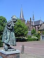 Beers, church and statue of child dressed up as elderly woman
 -
 Bandstand
 -
 View on Beers


References
- ^ a b c "Kerncijfers wijken en buurten 2021". Central Bureau of Statistics. Retrieved 17 April 2022.
- ^ "Postcodetool for 5437AA". Actueel Hoogtebestand Nederland (in Dutch). Het Waterschapshuis. Retrieved 17 April 2022.
- ^ Statistics Netherlands, 2007. Figures are for the year 2006. Statistics are available in Google Earth format. Statistical areas "Beers" and "Verspreide huizen Beers".
- ^ Ad van der Meer and Onno Boonstra, Repertorium van Nederlandse gemeenten, KNAW, 2011.
- v
- t
- e
Populated places in the municipality of Land van Cuijk
- Beert
- Beugen
- Escharen
- Gassel
- Groeningen
- Haps
- Holthees
- Katwijk [nl]
- Landhorst [nl]
- Langenboom
- Ledeacker [nl]
- Linden
- Maashees [nl]
- Mill
- Oeffelt
- Oploo
- Overloon
- Rijkevoort
- Sambeek
- Sint Agatha [nl]
- Sint Anthonis
- Sint Hubert
- Stevensbeek [nl]
- Velp
- Vianen [nl]
- Vierlingsbeek
- Vortum-Mullem [nl]
- Wanroij
- Westerbeek [nl]
- Wilbertoord [nl]
 | This North Brabant location article is a stub. You can help Wikipedia by expanding it. |
- v
- t
- e


